Saturday – September 9th

Banks of the Ohio
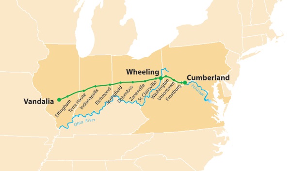
Crossed Ohio River on ferry at Henderson, KY. Went from there to Evansville, Ind. A city of 100,000 population. Very pretty place on the banks of the Ohio. The people were very nice. Called on Mr. Miller who had made several trips to Cal. Got some good information. Met man supposed to be from Charlotte, NC. Left a bad impression. Left Evansville about noon-camped near Vincennes in a large grove near farm house. The people were very nice. The roads are very good. Tonight one week ago went to see “Lib E.” (E for Easley) and also “Lib N.” (N for Newman)

The banks of the Ohio
Approximate mileage 105 miles.
Lib E is Lib Easley and Lib N is Lib Newman. They continued on the Magnolia Route all day. The ferry they took from Henderson crossed the river into what was known as Union Township, a part of Evansville. The ferry was probably the Katherine. From the Indiana side, they would have taken the old Henderson Road north from there into Evansville. There is no way to traverse that route today as there is a railroad bridge but no ferries or auto bridge.
|
Evansville River View |
Evansville Birds Eye View |
 Henderson Ferry |
Sunday – September 10th
Went about 60 miles North to Terre Haute where we struck the National Highway. Paved road to St Louis 180 miles. A car in front of us ran over a chicken and we picked it up, cleaned it and had it for supper. Began to rain about 3:30 so we stopped at a farm house. The old man didn’t want us to stay-afraid we were crooked. We assured him we wouldn’t take his well so he finally consented to let us stay. We slept in his corn crib. Hard as a rock and turned cold too so we didn’t sleep very much.
 Terre Haute |
 Wabash Bridge at Terre Haute |
Approximate mileage 221 miles. They were on Magnolia Route until Terre Haute where they began traveling the National Highway.

Mitch with the chicken. Ben in the car.
The National Highway, also known as the Cumberland Road, was the first major improved highway in the US to be built by the federal government. It was started in 1831. It was the first road in the U.S. to use macadam road surfacing, a method which used single-sized aggregate layers of small stones, mixed with a coating of binder, as a cementing agent in an open-structured roadway. After the panic of 1837 money ran out and so the road stopped in Vandalia, Illinois. In 1912, the Cumberland National Road was chosen to become part of the National Old Trails Road. This road would extend east to New York City and west to San Francisco. Five Madonna of the Trail monuments, donated by the Daughters of the American Revolution, were erected along the old National Road.
They traveled part of the Victory Highway and the National Old Trails Road which both follow highway 40 now.
The Victory Highway Association was organized in 1921. Its purpose was to locate and mark a transcontinental highway from New York City to San Francisco (sound familiar) via St. Louis. The road was to be dedicated to American forces that died in the World War, and a series of Victory Eagle sculptures marked the route. Part of the road was made from the Old National Road to Vandalia, Illinois.
The National Old Trails Road was also known as the Ocean to Ocean Highway. It was started in 1912. It was 3,096 miles long and stretched from Baltimore to California. In 1927 only 800 miles of the road were paved.
Other National Old Trails Links
 The bridge over the Wabash River in Terre Haute |
 National Old Trails Map |
 National Old Trail Road Marker |
 Victory Highway Sign |
 Cumberland or National Highway Map |
 Madonna Statue in Vandalia |
 Cumberland Mile Post |
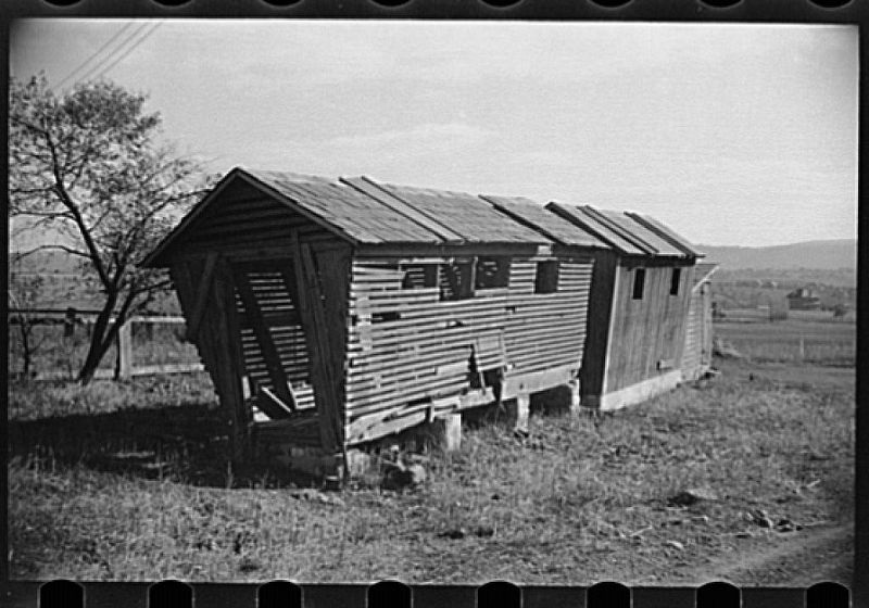
A corn crib is a place that is used to dry and store corn. It usually had slanted sides to keep water out, and was placed on stone or wooden posts so as to be high enough above the ground to discourage rodents.
 Corn Crib |
 Corn Crib inside |